Dawki to Cherrapunji: The journey
Dawki is a border town between India and Bangladesh, located in the Jaintia Hills of the northeastern state of Meghalaya. It is also known by a few people as 'Dauki'. The greenery of the hills around, the crystal clear water of the Umngot river and the purity of the environment overall will make you fall in love with Dawki.
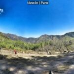
Dawki to Cherrapunji is about 85km distance which takes approximately 2 hours 30 mins depending on the traffic. The route offers a wide view of nature and spots where you can visit on your way.
When you leave out of Dawki, you will witness the road which goes through lush tropical forest and the sun adds more beauty to its sight. Various villages come by your way. Plenty of eateries option are for you on the way. Sohlang and Wahkdait are the first two villages on the way to NH 206. Lapalang and Pomshutia have many churches on the way where you can sit peacefully and enjoy the surrounding.
Pynursla
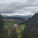
Pynursla one of the major town on this route is full of Khasi tribals following Christianity as their religion. The route has many scenic views of beautiful churches and view points to witness the Khasi hill. The town is a bustling one where you can see the local market. The town reminds one of an old school mountain hill town. The town looks colourful during the sunshine.
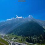
Moving forward you will get into Mawkajem village, before the turn which takes you to Cherrapunji. While coming from Dawki side you need to take the left road to reach out to the Y-point. The left side road will take you to Cherrapunji (Sohra) and one will take you to Shillong. The signboard is quite visible on the road. Once you start going on the route, you will get the sight of mountain ranges and open land.
Be careful during the monsoon season, this route could be extra foggy and visibility could be an issue. You can relish your soul at Shabong tea stall on your way. Keep your vehicle on the left side of the road to take a turn for Sohra.
Mawkdok Dympep Valley viewpoint
Look forward to Mawjrong village on NH 5. An interesting viewpoint named Mawkdok Dympep Valley viewpoint will come, where you can peacefully sit and enjoy nature. Often it happens that you admire something and that becomes a special moment for you with nature. Open vast mountain air makes you feel better. There's another activity you can do which takes a lot of determination and commitment called the David Scott trail.
David Scott was a British administrator and political agent. His operations lasted about 29 years (1802-1832) in the Khasi Hills and the surrounding low-lying areas. These areas are now part of Bangladesh and the Indian states of Meghalaya and Assam. One reminder of David Scott’s legacy is the horse-cart trail that he built from Cherrapunji, now also knows as Sohra, to Bangladesh.
This trail caused a war between the Khasi people, led by U Tirot Singh, King of the Khadsawphra Syiemship and the British. After four years of guerrilla-warfare style fighting, the Khasi forces were defeated by the British superior military strength. U Tirot Singh was captured and deported to Dhaka (now the capital of Bangladesh) where he died on July 17, 1835.
The route is filled with various waterfalls and nature spots where one can peacefully enjoy the surrounding. After Laitryngew village, the whole area belongs to Cherrapunji which is now known as Sohra.
-->For a similar experience, >>Click here
-->To plan a trip to North-East India, >>Click here